YATEB Mountain is located 30 KM of distance to the east of Hail city and its length amounts to 150m. and with a height of about 30m. it contains a group of Heritage’s evidence at the foot of the mountain and its summit a group of old Arabic northern inscriptions (THAMOUDIAN) are spread with more than 154 texts the majority of which were memories inscription type. YATEB mountain is also distinguished by historical sites surrounding it with more rock arts with various subjects and beside the Human shapes with its miscellaneous methods there are many Animals pictures such as sheep, Camels, Horses, Cows some of which were drawn in natural volume and others are drawn by pictures with full bodies which means the surplus of plants cover at the site and that participated in the sufficient nutrition of the animal livestock, however, what is most important for YATEB mountain to distinguish with is the rock arts surplus of the Palm Trees which reflects an aspect of Agriculture Wealth.
Janin Mountain is located 60KM of distance north -east of Hail city with a cave in there and contains a big amount of rock arts and written inscription. The length of the cave is 30m with a height round about 7-8m and round the cave entrance there was an inscription a group of palm fingerprints which we could refer its history back to the ancient stone age. Also, from the rock arts existing in Janin mountain the shapes of cows, Ibex, camels, in addition to human shapes. The dancing scenes are considered the most beautiful paintings in Janin whereat a group of human being were seen includes between twelve to fifteen dancers performing the dances while holding each other hands, and there were masks on their faces of no human features appear rather near to horses and donkeys faces.
FAYED city in Hail is considered of the ancient historical and heritage of cities located in the eastern area of Hail city and far away about 120KM and considered the third city to the old pilgrimage road (Zubaida - rout) after KUFA AND AL-BASRA which is the biggest station on the Iraqi pilgrimage road (Zubaida -Rout). QAYED is considered one of the distinguished historical and heritage sites being having big historical storage and contains of many ruins the most distinguished of which is the historical KHARASH Palace and the housing city the Ponds, wells, and water channels. The remaining heritages of QAYED old city grounded on north of the modern city with 1.5KM, and the area of the Historical site reaches over 1.5 KM and same in width. QAYED occupied a special position in Al-Abbassi era and was considered the most important city after Baghdad city and Makkah being in the middle of the road between Baghdad and Makkah on the old pilgrimage road or as what is known (Zubaidah rout) and was one of the cities comparable in value and expansion to Kufa and Basra at that time and was named “Road Capital” wherein the pilgrims take their rest and provided with what they need from supplies and was mentioned by many Historians such as Ibn Jubair, Ibn Battuta,, Ibn Kardinia, and other Historians and mentioned as well by number of Authors of Western travelers.
It is an old citadel located in the heart of Hail city above a mountain summit overviewing the city and to whom the name of the citadel was attributed to such name. The citadel was established in the era of the ALL-ALI family who took ruling Hail 1205H to 1790G, the citadel is rectangular in shape its dimensions reach 40 and 11 meters, and its area reaches round about 440 SM. And its walls were constructed of soft brick on stone bases, and the citadel is equipped with all what it needs from cleats and cannons defending the citadel and the city with spaces allocated to sleeping and other spaces for storage, praying area, Water Closets beside the only tower which is in the east of the citadel. The citadel is distinguished with its big wooden gates engraved with the area inscription and is distinguished with high tower which takes gradual conical shape for each side. The citadel was transformed in the modern ages to a location through which the crescent of Ramadan is observed and the IFTAR Cannon is fired before it turns into a tourist attraction at present time
It is located in ALGHAZAL Province IN THE SOUTHERN AREA OF Hail and west to Rumman famous mountain, and is considered one of the beautiful tourism sites being its historical buildings surrounded by palm trees an element to attract visitors, however its mud houses were restored and corridors and services were prepared to the visitors by the General Authority to Tourism and National Heritage previously and with the cooperation with ALGHAZAL Municipality and some of its dates existing in some buildings indicate that its construction was made in 1111 H i.e., more than 300 years approximately. ALGHAZALA is enriched with some historical landmarks the outstanding of which is the country wall consisting of two thick walls filled with dust in between to isolate the pullets of the enemy, this country wall was established by the order of IMAM TURKI BIN ABDULLAH Najd Ruler and there are many other fortified citadels being its existence so far indicating its strong construction.
Barzan Palace is a historical palace located in the city of Hail and is considered one of its well-known heritage landmarks. I t was named Barzan (meaning eminent) because it was the tallest building at the time, the maintained his presence at political events and occasions in Hail region. Although the palace was a large building, parts of it were demolished, left of only the two towers that surrounded it. The diameter of the northern tower is seven meters, while the diameter of the southern tower is five meters, and the height of each is ten meters.
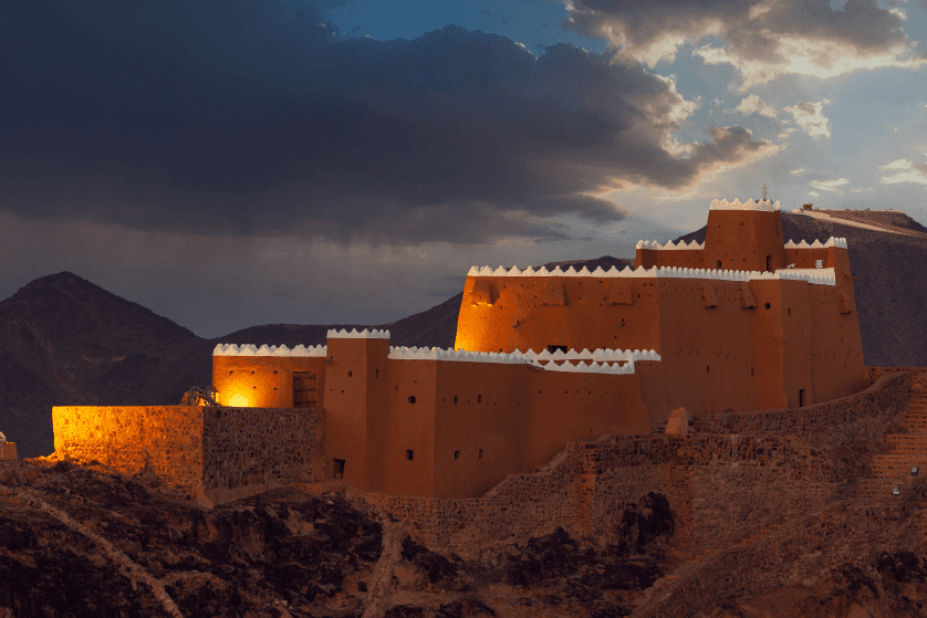
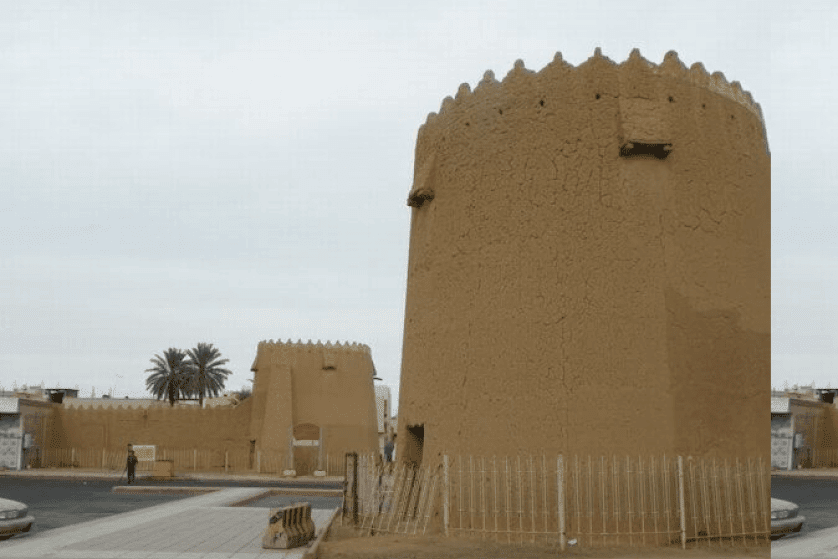
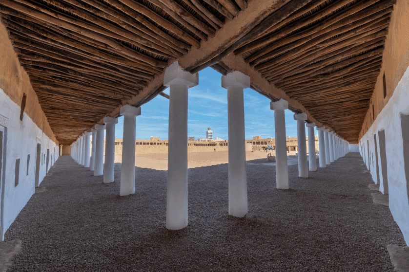
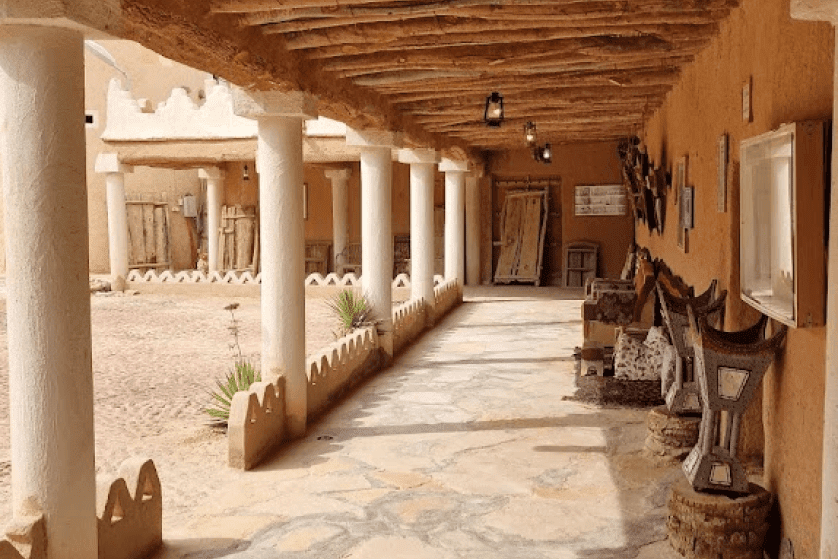
The historic Al Qishla Palace is one of the important landmarks in the city of Hail, as it was a military fort used to equip armies and a security headquarters for more than eight decades ago. During the reign of the founder, King Abdul Aziz - may Allah have mercy on him - specifically in 1941 AD, the historic “Al-Qishla” Palace was built. It is a square-shaped mud building consisting of two floors, with an area of approximately 19,832 square meters, a length of 142 meters and a width of 141 meters, and the height of the walls is 10 meters. Inside it, there are about 391 pillars and eight large squares. It also contains 83 rooms on the ground floor, and 59 rooms on the first floor. In addition to other service buildings, it has four square-shaped towers in the middle, in addition to four square-shaped towers in the middle of its walls, called “support towers.” The height of the eight towers is 12 meters. The palace includes two entrances, a main entrance of which is located in the middle of the eastern facade of the building and is surrounded by numerous decorations, and the other is located on the southern side, and is the entrance currently used for the entry of visitors and guests.
Tuwarin is a Saudi village, located in Hail region on the banks of a valley on the northwestern mountainside of Aja Mountain. It is approximately 55 km away from the city of Hail. It was inhabited in the past by Hatem Al-Taie, and it contains his grave. There is a fort at the entrance to the village, the ruins of which are still standing, and it is said that it was Hatem’s palace. There are also the ruins of a mud palace located in the center of the village and a small cemetery nearby that contains two graves. It is said that one of the graves is that of Hatem al-Tai.
A heritage village characterized by agriculture, located south of the city of Al Hait in Hail region. It is about 250 km away from the city of Hail with a maximum length of 1,200 meters, and maximum width of 600 meters. The heritage village is a unique example of late Islamic architecture in the Kingdom of Saudi Arabia.
It is located in the city of Jubbah and was built by its prince Atiq bin Muslim bin Farhan in 1171/1758 AD. The palace was constructed of mud and included a sitting place (Majlis) with an area of about sixty square meters. There is an old well in the palace that was drilled before the palace was built. The palace’s rooms are now used to display some artifacts, a number of agricultural products, the products of some of the region's handicrafts, in addition to thousands of ancient artifacts that reflect several historical stages that went through the region, which are located next to the desert. The artifacts include coffee tools, some old clothes, jewelry, and women’s toiletries, as well as sewing tools, leather goods such asbags and Nataa(leather rugs), and many copper tools, such as coffee pots, Sahal, and Safari for storing drinking water. It also includes a collection of weapons and war tools.